Network area allocation and geodata
According to Article 5 paragraph 1 of the Electricity Supply Act (StromVG, SR 734.7), the cantons shall designate the network areas on their territory.
Since Network Level 1 (the transmission network) is operated solely by the national grid operator (Swissgrid), the cantons only have to allocate network areas at Voltage Levels 3, 5 and 7. The network areas are allocated to cover the entire cantonal territory, usually by a decree by the executive or the parliaments in the cantons.
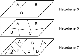
The following figure shows an example of how the network area allocation can be carried out via Network Levels 3, 5 and 7.
In accordance with the Geoinformation Ordinance (GeoIV, SR 620), ElCom is responsible for defining Minimal Geodata Model 183.1 (Security of Electricity Supply: Network Areas).
All cantons have allocated their grid areas and provided their GIS data for grid area allocation to geoservices under “Security of the electricity supply: grid areas” for further automated use.
A possible use of the data from the grid area allocation is visualized under the following link. If you select the desired location on the map, the information stored on the network level and the network operator is displayed in the object information. All cantons indicate the network area allocation for network level 7, many cantons also indicate the network area allocation for network level 5 and some cantons additionally indicate the network area allocation for network level 3.